 Another postscript to my posts of a couple of weeks ago on blogging and Blogspot in Syria (see my last post and the postscript before it): after uploading the posts below, I received loads of emails and tweets from around the world, from Syrians asking everything from why I couldn't go to an internet cafe where it's often possible to access Blogspot (sorry, we were working 16-hour days so the only time I had to email was early morning or late at night at our hotels) to foreign and local censorship/IT experts wanting me to provide them with a list of every hotel we stayed at and the hotel's proxy info (apologies again, but one of the things we were doing in Syria was reviewing hotels, so we were moving hotels every second day, and I had enough to do as it was). Based on my recent experience ('recent', because I've never had time to blog on previous trips to Syria), my advice to you is if you're planning to travel to Syria and blog regularly, do your research first but research widely: there are plenty of experts eager to share their opinions (indeed, some rather aggressively) and there is a lot of contradictory advice around (even among the self-proclaimed "experts") about blogging and Blogspot in Syria, from people both outside and within Syria. I found that rarely did opinions align and every expert was able to cite a wealth of research on the subject. Once again, I apologise for not having time to test out your theories and suggestions, but I'm a travel writer who also blogs, rather than a travel blogger who also publishes - and that's likely to stay that way until someone pays me as much to blog as I earn writing. The paid work - which one charming "expert" referred to as "travel fluff" (rest assured, I took her as seriously as she took me) has to take priority, I'm afraid. So, back to work... or writing nonsense?
Monday, August 31, 2009
Postcript: blogging and Blogspot in Syria
Another postscript to my posts of a couple of weeks ago on blogging and Blogspot in Syria (see my last post and the postscript before it): after uploading the posts below, I received loads of emails and tweets from around the world, from Syrians asking everything from why I couldn't go to an internet cafe where it's often possible to access Blogspot (sorry, we were working 16-hour days so the only time I had to email was early morning or late at night at our hotels) to foreign and local censorship/IT experts wanting me to provide them with a list of every hotel we stayed at and the hotel's proxy info (apologies again, but one of the things we were doing in Syria was reviewing hotels, so we were moving hotels every second day, and I had enough to do as it was). Based on my recent experience ('recent', because I've never had time to blog on previous trips to Syria), my advice to you is if you're planning to travel to Syria and blog regularly, do your research first but research widely: there are plenty of experts eager to share their opinions (indeed, some rather aggressively) and there is a lot of contradictory advice around (even among the self-proclaimed "experts") about blogging and Blogspot in Syria, from people both outside and within Syria. I found that rarely did opinions align and every expert was able to cite a wealth of research on the subject. Once again, I apologise for not having time to test out your theories and suggestions, but I'm a travel writer who also blogs, rather than a travel blogger who also publishes - and that's likely to stay that way until someone pays me as much to blog as I earn writing. The paid work - which one charming "expert" referred to as "travel fluff" (rest assured, I took her as seriously as she took me) has to take priority, I'm afraid. So, back to work... or writing nonsense?Friday, August 28, 2009
Beauty Place Sport for Diving of Raja Ampat Island
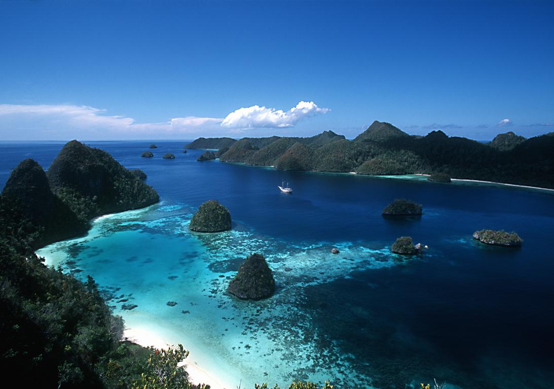


Beauty Place Sport for Diving of Raja Ampat Island :
Located off the northwest tip of Bird’s Head Peninsula on the island of New Guinea, Raja Ampat, or the Four Kings, is an archipelago comprising over 1,500 small islands, cays and shoals. Put simply, Raja Ampat diving is the bees knees in the world of scuba. If you don’t enjoy your dives here, you may as well sell your dive gear! According to the Conservation International Rapid Assessment Bulletin, the marine life diversity for scuba diving in Irian Jaya is considerably greater than all other areas sampled in the coral triangle of Indonesia, Philippines and Papua New Guinea – the cream of the cream in world diving. Over 1,200 fish species – a world record 284 on one single dive at Kofiau Island, the benchmark figure for an excellent dive site of 200 fish species surpassed on 51% of Raja Ampat dives (another world record), 600 coral species , 699 mollusc species – again another world high. The term “Frontier Diving” seems to have been invented for Raja Ampat in Irian Jaya. To visit these waters is to feel at the edge of the earth. To gaze over crystalline seas at the beehive-shaped, largely uninhabited islands is to be as far away from it all as you can imagine. At night time in Misool you can peer out at the horizon and maybe see one or two distant specks of light.
Located off the northwest tip of Bird’s Head Peninsula on the island of New Guinea, Raja Ampat, or the Four Kings, is an archipelago comprising over 1,500 small islands, cays and shoals. Put simply, Raja Ampat diving is the bees knees in the world of scuba. If you don’t enjoy your dives here, you may as well sell your dive gear! According to the Conservation International Rapid Assessment Bulletin, the marine life diversity for scuba diving in Irian Jaya is considerably greater than all other areas sampled in the coral triangle of Indonesia, Philippines and Papua New Guinea – the cream of the cream in world diving. Over 1,200 fish species – a world record 284 on one single dive at Kofiau Island, the benchmark figure for an excellent dive site of 200 fish species surpassed on 51% of Raja Ampat dives (another world record), 600 coral species , 699 mollusc species – again another world high. The term “Frontier Diving” seems to have been invented for Raja Ampat in Irian Jaya. To visit these waters is to feel at the edge of the earth. To gaze over crystalline seas at the beehive-shaped, largely uninhabited islands is to be as far away from it all as you can imagine. At night time in Misool you can peer out at the horizon and maybe see one or two distant specks of light.
Monday, August 24, 2009
Beautifu Place of Komodo National Park


Komodo National Park lies in the Wallacea Region of Indonesia, identified by WWF and Conservation International as a global conservation priority area. The Park is located between the islands of Sumbawa and Flores at the border of the Nusa Tenggara Timur (NTT) and Nusa Tenggara Barat (NTP) provinces. It includes three major islands, Komodo, Rinca and Padar, and numerous smaller islands together totaling 603 km2 of land. The total size of Komodo National Park is presently 1,817 km2. Proposed extensions of 25 km2 of land (Banta Island) and 479 km2 of marine waters would bring the total surface area up to 2,321 km2.
History :
Komodo National Park was established in 1980 and was declared a World Heritage Site and a Man and Biosphere Reserve by UNESCO in 1986. The park was initially established to conserve the unique Komodo dragon (Varanus komodoensis), first discovered by the scientific world in 1911 by J.K.H. Van Steyn. Since then conservation goals have expanded to protecting its entire biodiversity, both marine and terrestrial.
The majority of the people in and around the Park are fishermen originally from Bima (Sumbawa), Manggarai, South Flores, and South Sulawesi. Those from South Sulawesi are from the Suku Bajau or Bugis ethnic groups. The Suku Bajau were originally nomadic and moved from location to location in the region of Sulawesi, Nusa Tenggara and Maluku, to make their livelihoods. Descendents of the original people of Komodo, the Ata Modo, still live in Komodo, but there are no pure blood people left and their culture and language is slowly being integrated with the recent migrants.
Little is known of the early history of the Komodo islanders. They were subjects of the Sultanate of Bima, although the island’s remoteness from Bima meant its affairs were probably little troubled by the Sultanate other than by occasional demand for tribute.
DEMOGRAPHICS :
There are presently almost 4,000 inhabitants living within the park spread out over four settlements (Komodo, Rinca, Kerora, and Papagaran). All villages existed prior to 1980 before the area was declared a national park. In 1928 there were only 30 people living in Komodo Village, and approximately 250 people on Rinca Island in 1930. The population increased rapidly, and by 1999, there were 281 families numbering 1,169 people on Komodo, meaning that the local population had increased exponentially.
Komodo Village has had the highest population increase of the villages within the Park, mostly due to migration by people from Sape, Manggarai, Madura, and South Sulawesi. The number of buildings in Kampung Komodo has increased rapidly from 30 houses in 1958, to 194 houses in 1994, and 270 houses in 2000. Papagaran village is similar in size, with 258 families totaling 1,078 people. As of 1999, Rinca’s population was 835, and Kerora's population was 185 people. The total population currently living in the Park is 3,267 people, while 16,816 people live in the area immediately surrounding the Park.
EDUCATION :
The average level of education in the villages of Komodo National Park is grade four of elementary school. There is an elementary school located in each of the villages, but new students are not recruited each year. On average, each village has four classes and four teachers. Most of the children from the small islands in the Kecamatan Komodo (Komodo, Rinca, Kerora, Papagaran, Mesa) do not finish elementary school. Less than 10% of those which do graduate from elementary school will continue to high school since the major economic opportunity (fishing) does not require further education. Children must be sent to Labuan Bajo to attend high school, but this is rarely done in fishermen’s families.
HEALTH :
Most of the villages located in and around the Park have few fresh water facilities available, if any, particularly during the dry season. Water quality declines during this time period and many people become ill. Malaria and diarrhea are rampant in the area. On Mesa island, with a population of around 1,500 people, there is no fresh water available. Fresh water is brought by boat in jerrycans from Labuan Bajo. Each family needs an average of Rp 100,000.- per month to buy fresh water (2000). Almost every village has a local medical facility with staff, and at least a paramedic. The quality of medical care facilities is low.
SOCIO-CULTURAL AND ANTHROPOLOGIC CONDITIONS :
Traditional Customs: Traditional communities in Komodo, Flores and Sumbawa have been subjected to outside influences and the influence of traditional customs is dwindling. Television, radio, and increased mobility have all played a part in accelerating the rate of change. There has been a steady influx of migrants into the area. At the moment nearly all villages consist of more than one ethnic group.
Religion: The majority of fishermen living in the villages in the vicinity of the Park are Muslims. Hajis have a strong influence in the dynamics of community development. Fishermen hailing from South Sulawesi (Bajau, Bugis) and Bima are mostly Moslems. The community from Manggarai are mostly Christians.
Anthropology and Language: There are several cultural sites within the Park, particularly on Komodo Island. These sites are not well documented, however, and there are many questions concerning the history of human inhabitance on the island. Outside the Park, in Warloka village on Flores, there is a Chinese trading post remnant of some interest. Archeological finds from this site have been looted in the recent past. Most communities in and around the Park can speak Bahasa Indonesia. Bajo language is the language used for daily communication in most communities.
TERRESTRIAL PHYSICAL ENVIRONMENT :
Topography: The topography is varied, with slopes from 0 – 80%. There is little flat ground, and that is generally located near the beach. The altitude varies from sea level to 735 m above sea level. The highest peak is Gunung Satalibo on Komodo Island.
Geology: The islands in Komodo National Park are volcanic in origin. The area is at the juncture of two continental plates: Sahul and Sunda. The friction of these two plates has led to large volcanic eruptions and caused the up-thrusting of coral reefs. Although there are no active volcanoes in the park, tremors from Gili Banta (last eruption 1957) and Gunung Sangeang Api (last eruption 1996) are common. West Komodo probably formed during the Jurasic era approximately 130 million years ago. East Komodo, Rinca, and Padar probably formed approximately 49 million years ago during the Eocene era.
Climate: Komodo National Park has little or no rainfall for approximately 8 months of the year, and is strongly impacted by monsoonal rains. High humidity levels year round are only found in the quasi-cloud forests on mountain tops and ridges. Temperatures generally range from 170C to 340C, with an average humidity level of 36%. From November through March the wind is from the west and causes large waves that hit the entire length of Komodo island’s west beach. From April through October the wind is dry and large waves hit the south beaches of Rinca and Komodo islands.
TERRESTRIAL ECOSYSTEMS :
The terrestrial ecosystems are strongly affected by the climate: a lengthy dry season with high temperatures and low rainfall, and seasonal monsoon rains. The Park is situated in a transition zone between Australian and Asian flora and fauna. Terrestrial ecosystems include open grass-woodland savanna, tropical deciduous (monsoon) forest, and quasi cloud forest.
Due to the dry climate, terrestrial plant species richness is relatively low. The majority of terrestrial species are xerophytic and have specific adaptations to help them obtain and retain water. Past fires have selected for species that are fire-adapted, such as some grass species and shrubs. Terrestrial plants found in Komodo National Park include grasses, shrubs, orchids, and trees. Important food tree species for the local fauna include Jatropha curkas, Zizyphus sp., Opuntia sp., Tamarindus indicus, Borassus flabellifer, Sterculia foetida, Ficus sp., Cicus sp., ‘Kedongdong hutan’ (Garuga floribunda), and ‘Kesambi’ (Schleichera oleosa).
TERRESTRIAL FAUNA :
The terrestrial fauna is of rather poor diversity in comparison to the marine fauna. The number of terrestrial animal species found in the Park is not high, but the area is important from a conservation perspective as some species are endemic. Many of the mammals are Asiatic in origin (e.g., deer, pig, macaques, civet). Several of the reptiles and birds are Australian in origin. These include the orange-footed scrubfowl, the lesser sulpher-crested cockatoo and the nosy friarbird.
Reptiles: The most famous of Komodo National Park's reptiles is the Komodo Dragon (Varanus komodoensis). It is among the world's largest reptiles and can reach 3 meters or more in length and weigh over 70kg.
Other than the Komodo Dragon twelve terrestrial snake species are found on the island. including the cobra (Naja naja sputatrix), Russel’s pit viper (Vipera russeli), and the green tree vipers (Trimeresurus albolabris). Lizards include 9 skink species (Scinidae), geckos (Gekkonidae), limbless lizards (Dibamidae), and, of course, the monitor lizards (Varanidae). Frogs include the Asian Bullfrog (Kaloula baleata), Oreophyne jeffersoniana and Oreophyne darewskyi. They are typically found at higher, moister altitudes.
Mammals: Mammals include the Timor deer (Cervus timorensis), the main prey of the Komodo dragon, horses (Equus sp.), water buffalo (Bubalus bubalis), wild boar (Sus scrofa vittatus), long-tailed macaques (Macaca fascicularis), palm civets (Paradoxurus hermaphroditus lehmanni), the endemic Rinca rat (Rattus rintjanus), and fruit bats. One can also find goats, dogs and domestic cats.
Birds: One of the main bird species is the orange-footed scrub fowl (Megapodius reinwardti), a ground dwelling bird. In areas of savanna, 27 species were observed. Geopelia striata and Streptopelia chinensis were the most common species. In mixed deciduous habitat, 28 bird species were observed, and Philemon buceroides, Ducula aenea, and Zosterops chloris were the most common.
MARINE PHYSICAL ENVIRONMENT :
The marine area constitutes 67% of the Park. The open waters in the Park are between 100 and 200 m deep. The straits between Rinca and Flores and between Padar and Rinca, are relatively shallow (30 to 70 m deep), with strong tidal currents. The combination of strong currents, coral reefs and islets make navigation around the islands in Komodo National Park difficult and dangerous. Sheltered deep anchorage is available at the bay of Loh Liang on Komodo’s east coast, the South East coast of Padar, and the bays of Loh Kima and Loh Dasami on Rinca. In the North of the Park water temperature ranges between 25 – 29°C. In the middle, the temperature ranges between 24 and 28°C. The temperatures are lowest in the South, ranging from 22 – 28°C. Water salinity is about 34 ppt and the water is quite clear, although the waters closer to the islands are relatively more turbid.
MARINE ECOSYSTEMS :
Indonesia is the only equatorial region in the world where there is an exchange of marine flora and fauna between the Indian and Pacific oceans. Passages in Nusa Tenggara (formerly the Lesser Sunda Islands) between the Sunda and Sahul shelves allow movement between the Pacific and Indian oceans. The three main ecosystems in Komodo National Park are seagrass beds, coral reefs, and mangrove forests. The Park is probably a regular cetacean migration route.
MARINE FLORA :
The three major coastal marine plants are algae, seagrasses and mangrove trees. Algae are primitive plants, which do not have true roots, leaves or stems. An important reef-building algae is the red coralline algae, which actually secretes a hard limestone skeleton that can encrust and cement dead coral together. Seagrasses are modern plants that produce flowers, fruits and seeds for reproduction. As their name suggests, they generally look like large blades of grass growing underwater in sand near the shore. Thallasia sp. and Zastera spp. are the common species found in the Park. Mangroves trees can live in salty soil or water, and are found throughout the Park. An assessment of mangrove resources identified at least 19 species of true mangroves and several more species of mangrove associates within the Park's borders.
MARINE FAUNA :
Komodo National Park includes one of the world's richest marine environments. It consists of forams, cnidaria (includes over 260 species of reef building coral), sponges (70 species), ascidians, marine worms, mollusks, echinoderms, crustaceans, cartilaginous and bony fishes (over 1,000 species), marine reptiles, and marine mammals (dolphins, whales, and dugongs). Some notable species with high commercial value include sea cucumbers (Holothuria), Napoleon wrasse (Cheilinus undulatus), and groupers.
PARK FACILITIES :
The Komodo National Park administrative offices are located in Labuanbajo in west Flores. An information center and travel agents where transportation to and from the Park can be arranged are also found in Labuanbajo. The majority of tourists to the Park pass through the Loh Liang ranger station nestled in the sweeping arc of Slawi Bay on Komodo island. This is the largest facility in Komodo National Park with bungalows and rooms, a restaurant and a dormatory for the park rangers. The most popular tourist activity is a hike to the Banugulung viewing area, a two-hour roundtrip level walk that originates from Loh Liang. Hikes to other areas of Komodo are also possible, and vary from one to two days: Gunung Ara, Poreng, Loh Sebita, Gunung Sata libo, Soro Masangga. On longer walks overnight accommodation can be arranged at ranger posts at Loh Sebita and Loh Genggo. For certified divers there is a compressor and diving equipment available for hire at Loh Liang as well as masks and fins for snorkellers. Handicrafts made in the nearby village of Komodo are for sale at the arrival jetty.
The entrance ticket to Komodo National Park costs Rp 20,000 and is valid for three days. It is easily renewable, so a prolonged stay in the park is possible. There are two ranger stations which provide spartan accommodation for tourists: Loh Liang on Komodo and Loh Buaya on Rinca. The charges are minimal and start at Rp 30,000 per room. Be advised that everything is basic, including beds, communal toilets and food availability. Fortunately most travellers are not deterred by the limited facilities, accepting this as a part of the Komodo experience. Advance booking for accommodation are not accepted.
The hiking on Rinca is less strenuous than that on Komodo, and has the added attraction of viewing the wild horses and monkeys which are not found on Komodo. On Rinca wild buffalo are more common and easily seen as well. On the north side of the island, behind Rinca village, is a large cave with a resident bat colony. Rangers at both Loh Liang and Loh Buaya are readily available to lead walks, and are knowledgeable about the local fauna and birdlife.
Source: http://www.komodoisland-tours.com/komodo_national_park.html
Wednesday, August 19, 2009
Enjoy The Mount Elbrus in Russia

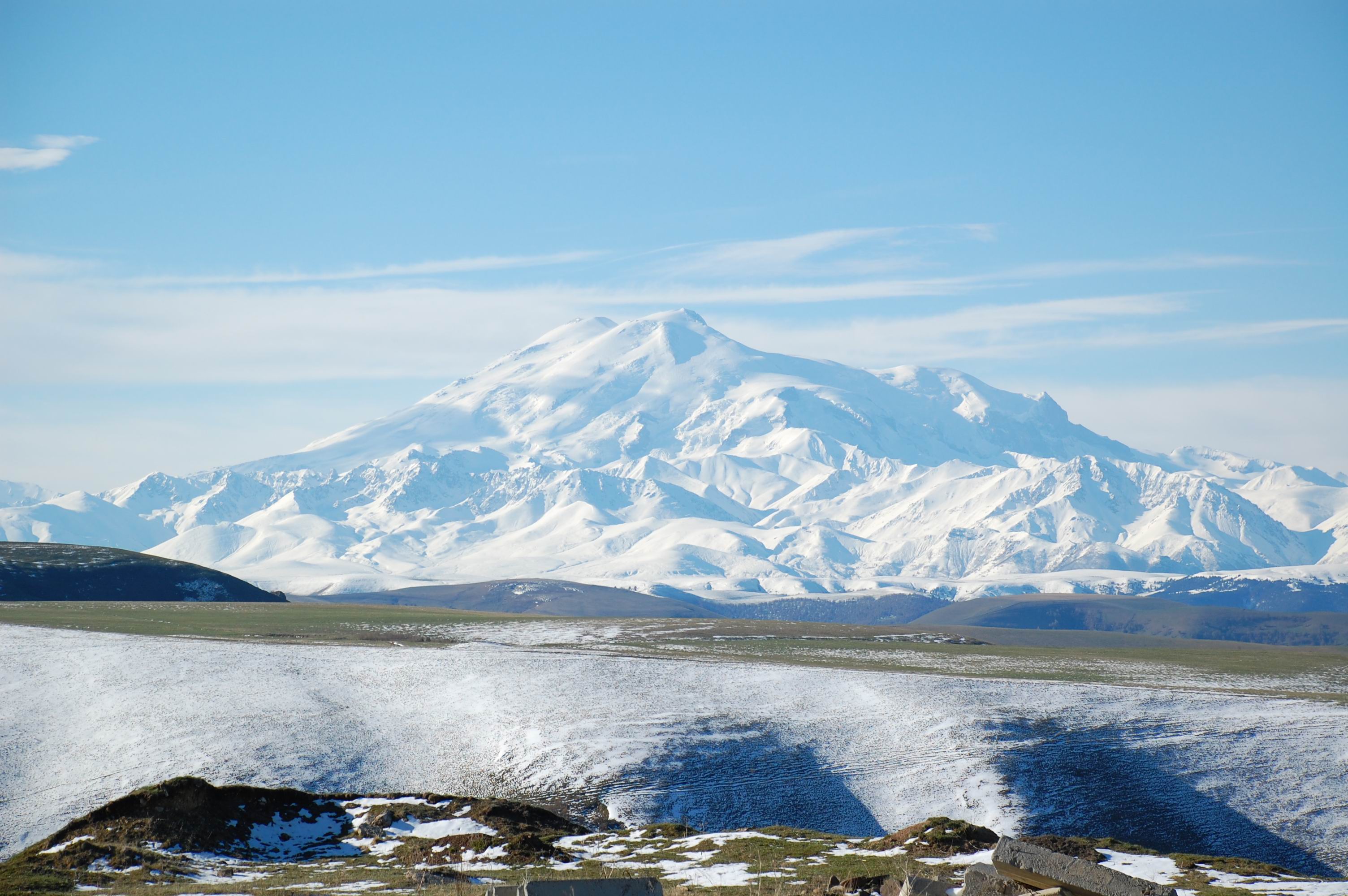


Mount Elbrus (Russian: Эльбрус) is an inactive volcano located in the western Caucasus mountain range, in Kabardino-Balkaria and Karachay-Cherkessia, Russia, near the border of Georgia. A stratovolcano that has lain dormant for about 2,000 years, it is the highest mountain in the Caucasus. Mt. Elbrus (west summit) stands at 5,642 metres (18,510 ft) and it is not only the highest mountain in Europe (depending on continental border used); it is also the highest point of Russia. The east summit is slightly lower: 5,621 metres (18,442 ft).
Read ful history of Mount Elbrus in wikipedia
Read ful history of Mount Elbrus in wikipedia
Thursday, August 13, 2009
Blogging and Blogspot in Syria
 A number of people have contacted me via the comments to my post below and on Twitter in response to my appeal for advice after my blog was momentarily blocked in Syria. Shukran jazeelan to everyone for their tips - much appreciated! Unfortunately (or fortunately), I'm a busy travel writer with a lot to do here in Syria at the moment - boutique hotels to review, restaurants to try out, artists and musicians to interview - and blogging is not high on my list of priorities at the moment sadly, so I don't have time to test out all your suggestions now. In addition to my lack of time, the intermittent and excruciatingly slow internet access at a lot of the hotels we're staying at means I simply can't get on the net when it's convenient nor wait for photos to upload at the usual size I post them. And I don't have time to keep running back to the Four Seasons, which must have the fastest internet access in town. Quite a few people have written to me about blogspot being banned here and forwarded links supporting this (sorry, but I don't have time to respond to everyone), however, just for your info, I can access a large number of blogspot blogs that I usually read from other parts of the world from Syria (and I was able to access them on previous trips here too), including many listed on my own blogroll, and Syrian-based blogspot blogs that I don't normally read but have discovered on this trip. People are asking me what ISPs I am using and am I using proxies. As I am reviewing hotels, I am moving hotels every couple of days so I'm using whatever ISP the hotel is using and whether the hotel has a proxy or not, I'm sorry but I don't have time to investigate, and would rather be talking to a singer such as the wonderful Rasha Rizk than an IT guy. Hoping you understand.
Tuesday, August 11, 2009
Access momentarily denied
 My harmless little blog Cool Travel Guide has been blocked in Syria for a whole 24 hours - I was confronted with the dreaded "Access Denied" sign when I tried to update it yesterday. But, there's been a miracle, or someone came to their senses, and now I can access it. I realize my mistake - my Syrian advisors tell me it's because I used the 'I' word, which I'm not about to use again, so guess all you like. So, how did it get unblocked? Did the censors actually read the content and realise I was a 'friend' of Syria's? Just a travel writer who writes about places she loves and stays clear of politics? Or was it that the Minister for Information and her staff, who were staying at the same hotel as us last night, overheard my loud complaints to the general manager this morning? Either way, I can post for the moment, but if you don't hear from me again, you'll know why. Come and follow me on Twitter instead.
Post-script: this post and my tweets on Twitter generated scores of responses via email and Twitter about blogging in Syria. Most were friendly messages from Syrian bloggers, IT experts and officials, with tips on how to get around proxies, using Blogger/Blogspot and other blogging software in Syria, and advice on what's acceptable and what's not regarding blog content. I'm sorry I didn't have time to follow everyone's suggestions - it was an incredibly busy trip with little time for blogging unfortunately - but a huge thanks to everyone who got in touch.
Monday, August 10, 2009
Enjoy The Bunaken Beach : Bunaken is Beautfully Beach


Bunaken is one of Indonesia's most famous dive/snorkeling areas, and it draws scuba divers & snorkelers from all over the world. In addition to Bunaken itself, a rather featureless banana-shaped island, the National Park includes the neighboring islands of Manado Tua, a distinctive cone-shaped extinct volcano, Siladen, Montehagen, Nain, and Nain Kecil.The waters of Bunaken National Marine Park are extremely deep (1566 m in Manado Bay), clear (up to 35-40 m visibility), refreshing in temperature (27-29 C) and harbor some of the highest levels of biodiversity in the world. Pick any of group of interest - corals, fish, echinoderms or sponges - and the number of families, genera or species is bound to be astonishingly high.
About half an hour by a motorized outrigger canoe from Manado, Bunaken island is a veritable paradise for snorkelers and scuba enthusiasts. The coral reef off Bunaken island is particularly good for that and shouldn't be missed while you're in this region. The drop off wall at Liang Cove is not only rare in the world, as it's described by international divers as being spectacular with caves, gullies, and caverns harbouring an immense wealth of marine life. The water averages a balmy 28 degrees C and visibility is sensational (over) 30 m. The Bunaken sea garden is rich with colourful tropical marine life
About half an hour by a motorized outrigger canoe from Manado, Bunaken island is a veritable paradise for snorkelers and scuba enthusiasts. The coral reef off Bunaken island is particularly good for that and shouldn't be missed while you're in this region. The drop off wall at Liang Cove is not only rare in the world, as it's described by international divers as being spectacular with caves, gullies, and caverns harbouring an immense wealth of marine life. The water averages a balmy 28 degrees C and visibility is sensational (over) 30 m. The Bunaken sea garden is rich with colourful tropical marine life
Palmetto Point : The Top of Beach


Trinity Palmetto Point is one of 14 administrative parishes that make up Saint Kitts and Nevis. It ranks 6th in terms of size of all the parishes on Saint Kitts. The parish capital is Palmetto Point.
Aleppo's labyrinthine souqs
 Aleppo's labyrinthine medieval souq - or rather souqs within a souq - has long been one of our favorites in the Middle East, mainly because it has remained relatively untouched by tourism up until recent years - especially compared to Istanbul's Grand Bazzar and Cairo's Khan el Khalili. It's a place where locals shop for anything from women's underwear to camel meat, as much as backpackers haggle for hookah pipes and harem pants. Great buys include olive soap (buy the soap the locals buy, not the soap packaged for tourists), Syria's famous silk brocades and other textiles, and gutras (men's checked headscarves). These days you'll also find stores and stalls with their eyes on the growing tourist market selling jewellery, carpets, and brass and copperware, and spruikers on corners hustling for sales. But we prefer wandering the back-alleys, where the locals shop for their cheap plastic shoes, spangly fabrics, and children's clothes, offering a far more authentic experience.
Sunday, August 9, 2009
Beauty of British Virgin Island


The British Virgin Islands (BVI) is a British overseas territory, located in the Caribbean to the east of Puerto Rico. The islands make up part of the Virgin Islands archipelago, the remaining islands constituting the U.S. Virgin Islands. Technically the name of the Territory is simply the "Virgin Islands", but in practice since 1917 they have been almost universally referred to as the "British Virgin Islands" to distinguish the islands from the American Territory.[1] To add to the regional confusion, the Puerto Rican islands of Culebra, Vieques and surrounding islands began referring to themselves as the "Spanish Virgin Islands" as part of a tourism drive in the early 2000s. The British Virgin Islands consist of the main islands of Tortola, Virgin Gorda, Anegada and Jost Van Dyke, along with over fifty other smaller islands and cays. Approximately fifteen of the islands are inhabited. The capital, Road Town, is situated on Tortola, the largest island which is approximately 20 km (12 mi) long and 5 km (3 mi) wide. The islands have a total population of about 22,000, of whom approximately 18,000 live on Tortola.
The island has been used as a backdrop for many movies, and once you view it you can definitely see why – just the place where you would want to be shipwrecked. Needless to say, this tiny piece of paradise is a favorite island hopping spot.
A 360 degree ring of beautiful, pristine white sand encompasses island, and the beautiful aqua marine water appears to make the white sand brighter.The islands vegetation is located at the center, and there are only three rather tired looking palm trees on the entire island. The south end of the island has a pristine reef, and provides the perfect snorkeling environment. No need to go out too far to view tropical fish – many can be seen (and felt) as you wade out from shore into the crystal clear water.
This is a perfect Caribbean island picnic spot. While you dine, the graceful frigate birds circle overhead, and schools of flying fish skirt just above the water - they really don’t actually fly, but I can see why they would be easy to catch.And if one fantasy island isn’t enough, Green Cay is just yards away, and connected to Sandy Split by an extremely shallow coral shoal.Green Cay also offers great snorkeling, swimming and greats views of the beauty of BVI. And Sandy Cay is only minutes away.The British Virgin Islands is home to small, tiny pristine islands – each one with its on personality and charm.Finally British Virgin Island is so beautifully place for recreations.
Aleppo and our room with a view
 Aleppo is Syria's most atmospheric city after Damascus and it's our next favorite destination after the capital, the highlights for us being the medieval souq, the labyrinthine old quarters dotted around the inner-city, and the complex cuisine, arguably the most interesting in the Middle East. The new town with its stylish cafes - currently full of hip young Syrian expat kids home for the summer holidays - is pretty appealing too. We're here to do hotel reviews and a feature on Aleppo's oldest restaurant dynasty, as well as gather content for other stories, so we've been at the Aleppo Sheraton for a few days. While it can't compare in terms of atmosphere to Aleppo's myriad boutique hotels in restored old houses, the hotel's location, slapbang in the centre of Aleppo, mid-way between Al Jdeida and the souqs, is unbeatable. As is the comfort and space of our room, the big desk, and internet access - things that become more important to a writer and photographer on deadline than sleeping under an Ottoman-era ceiling, I'm afraid. Oh, and the views, pictured, are pretty special too.
Saturday, August 8, 2009
Abu Shady, the last of Syria's traditional storytellers still tells his tales
 One of our many reasons for coming to Syria this time was to interview Abu Shady, the last of the hakawati, or traditional storytellers. We last interviewed him almost two and half years ago when we were here to update our Lonely Planet Syria and Lebanon guidebook - that's the 'current' edition every Western traveller is clutching in their hands here now. (We're not using it ourselves - nor are we using any other guidebook - there's no need obviously after so many trips here, but it's interesting to see how many people have a guidebook *and* a guide - very different to last time when there were far more independent travellers around. Why people need help ordering a meal, I'll never know, but it's something I'm going to ponder in another post.) When we last spoke to Abu Shady he was conscious of his age, depressed that numbers of people attending his performances at Al Nawfara cafe in Damascus' Old City were dwindling, his biggest competition being cinema, TV and the internet, and was grooming his son to take over after he died. Ironically, now his nightly performances are packed (people even phone to book tables) and storytelling is more popular than ever (in line with a resurgence of interest by Syrians in everything old), yet he no longer wants his son to take over. Why? Because the pay is lousy. I guess there's a point artists reach when they're no longer prepared to go hungry (or allow their family to go hungry) for their art. I'll pop up the link to our story soon.
Friday, August 7, 2009
Damascus is Buzzing
 The atmosphere in Damascus is electric now, and the streets of the Old City more alive than we've seen them before - and we've been regular visitors since 1998. Summer traditionally sees Syrian expats from around the world returning home to spend time with their families while Damascus has long attracted Gulf Arab tourists escaping the sweltering summer temperatures of the Arabian Peninsula - while it's warm here now (low to mid 30s Celcius), the Gulf is scorching (average mid 40s Celcius), so Syria is a cool escape in comparison. But we're seeing travellers from all over the globe getting lost in the Old City's labyrinthine streets at the moment, including Europeans, Australians and Americans. By the look of their travelling gear - harem pants and hippy attire dominate backpacker wardrobes here - they were expecting a cheap destination. But Damascus now boasts an array of beautiful boutique hotels, an ever-growing number of fine restaurants, a handful of hip bars and stylish cafes, a lively arts and cultural scene, and an increasingly chic shopping area in the new city. We're reporting on all of these for magazines over the next week or two, so I'll try and share a few of our discoveries with you as we go.
Pictured? That's Naranj, a relatively 'new' restaurant by Damascene standards, which was very good - the buzzy atmosphere indicative of that found in the whole city at the moment. Although Naranj is not the best, and don't listen to anyone who tells you otherwise - that's a title reserved for Al Halabi at The Four Seasons Hotel, and I'll tell you why in detail very soon.
Enjoy the Vatican City in Italy


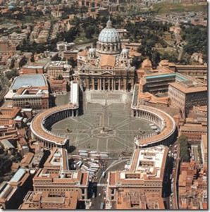
Italy is a developed democracy with a modern economy. The Holy See is a sovereign entity that serves as the ecclesiastical, governmental and administrative capital of the Roman Catholic Church, physically located within the State of the Vatican City inside Rome, with a unique, non-traditional economy. San Marino is a developed, constitutional democratic republic, also independent of Italy, with a modern economy. One of the most popular destination for trips to Italy is the Vatican. Many people do not know that the city is a sovereign state. This means that it makes its own rules, and independent oversight of the Italian system. Vatican City State walls in Rome. This is the Smallest independent country in the world, if only slightly to 100 acres. It was founded in 1929 by agreement between the Kingdom of Italy and the Holy See. The Holy See refers to the central nervous system of the Catholic Church headed by Pope. The Pope is also known as the Bishop of Rome. Houses of the official residence of the Vatican and the Pope visited by millions of people each year.
Thursday, August 6, 2009
Goodbye Dubai
 We spent our last night in the UAE in Dubai - stuck in a traffic jam, checking into our fully booked hotel, shopping for last minute necessities at busy Dubai Mall - packed with shoppers laden with shopping bags as late as midnight - and strolling the waterfront overlooking the new Burj Dubai, where tables at the outdoor restaurants and cafes were crammed with families, despite the 45 degree heat. It was the same old Dubai - not the 'ghost town' I'd be reading about in the media while we were in Australia. Ironically, summer has historically been the time of year when Dubai is usually a ghost town, when locals and expats who can leave the country for a couple of months evacuate for cooler climates for their summer vacation.
Pictured: the enormous aquarium at Dubai Mall.
Wednesday, August 5, 2009
Kilimanjaro : Beatiful Mount in The World

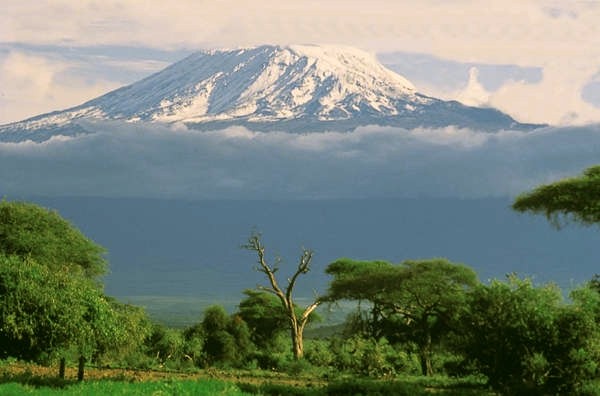

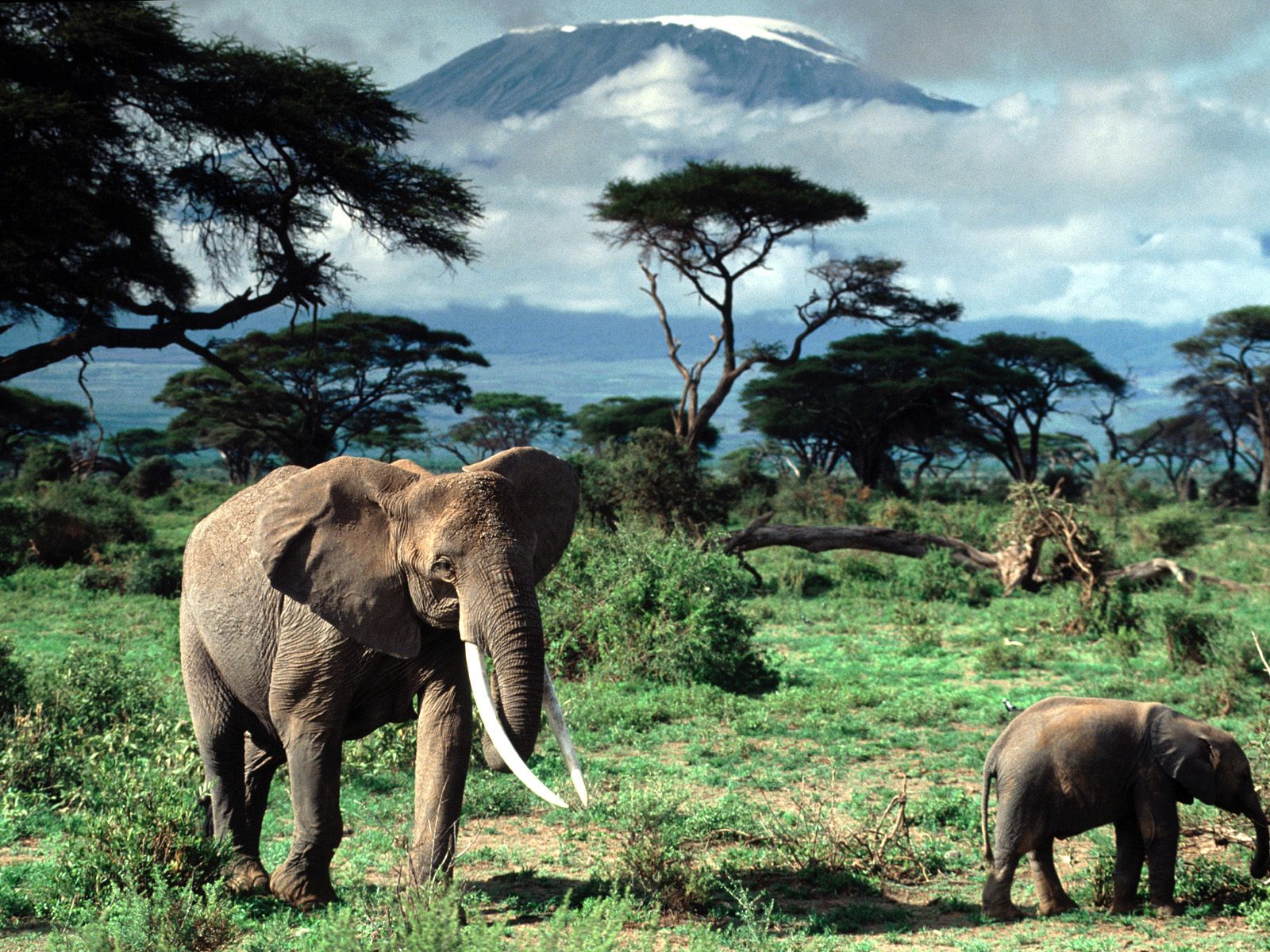

Kilimanjaro, with its three volcanic cones, Kibo, Mawenzi, and Shira, is an inactive stratovolcano in north-eastern Tanzania rising 4,600 m (15,100 ft) from its base (and approximately 5,100 m (16,700 ft) from the plains near Moshi), and is additionally the highest peak in Africa at 5,892 metres (19,331 ft)[4], providing a dramatic view of the surrounding plains.Ask people to think of a typical African mountain, and for many, Kilimanjaro might spring to mind. But it's far from typical, At 20,000 feet, it's the highest mountain in Africa, and one of only two to bear permanent snow (Mount Kenya is the other). Moreover, it is the largest mountain in the world that is free-standing; i.e., not part of a mountain range. To scale Mount Kilimanjaro is the ambition of many visitors to Africa. Indeed, for its height, it is a relatively easy climb relative to other mountains of a similar height. To walk up the gently sloping sides needs only stamina to withstand the thin air and long distances.
Tuesday, August 4, 2009
Travel with us on Twitter
 I might not get much time to blog over the next six weeks as we have a tight travel schedule, bouncing around the Middle East researching stories and doing hotel and restaurant reviews. So why not come and follow me on Twitter @laradunston?
One of the stories I've been commissioned to write is about how Twitter has been embraced in the MidEast and how it's being used. Twitter users are meeting socially at tweet-ups across the region, getting involved in charity work through Twestivals, and using Twitter for social change. If you're a Twitter user based in the UAE, Lebanon, Jordan, Kuwait or Qatar, or anywhere else around the Middle East, please email me or leave a comment here - I'd love to get in touch with you.
The photo pictured is the workspace of British writer-poet Robert Graves in his former home, now a museum, at Deia on Mallorca. It's the kind of space I'd love to write at. If I didn't live out of my suitcase, that is, and actually had a home in which to write... But who's going to feel sorry for a travel writer, right?
Subscribe to:
Comments (Atom)